Strong to severe thunderstorms will move into East Tennessee early Monday morning
Tod Hyslop tracks an area of severe thunderstorms as it approaches the WVLT viewing area with expected arrival around 3-5 am EDT.
KNOXVILLE, Tenn. (WVLT) - Skies will remain overcast and there may be an isolated shower in a few spots, but the evening hours will be relatively quiet as we await the arrival of the stronger thunderstorms early Monday morning.
Join us on the WVLT First Alert Weather app for iPhone or Android to stay informed. We share custom videos, and you can receive our messages on the latest conditions and forecasts at home.
WHAT TO EXPECT
Mesoscale forecast models have advanced the arrival time of the line of strong to possibly severe thunderstorms to around 2-3 a.m. CDT on the Cumberland Plateau, 3-4 a.m. EDT in the Knoxville area, and around 4-5 a.m. EDT over eastern sections of the viewing area, including cities like Sevierville, Pigeon Forge and Gatlinburg.
Intensity of the convective line may be slightly weakened by the resident cooler airmass across East Tennessee.
Thunderstorm strength is impacted by the temperature structure of the atmosphere. A warmer airmass provides stronger buoyancy for the storm updrafts and the region stayed just a little cooler than expected due to the overcast skies and relatively widespread shower activity that was around during the day. However, the possibility still exists for damaging winds and hail.
Once again, the threat for tornadoes is low, but cannot be ruled out; especially on the Cumberland Plateau where wind shear and instability will be in better supply ahead of the line of storms.
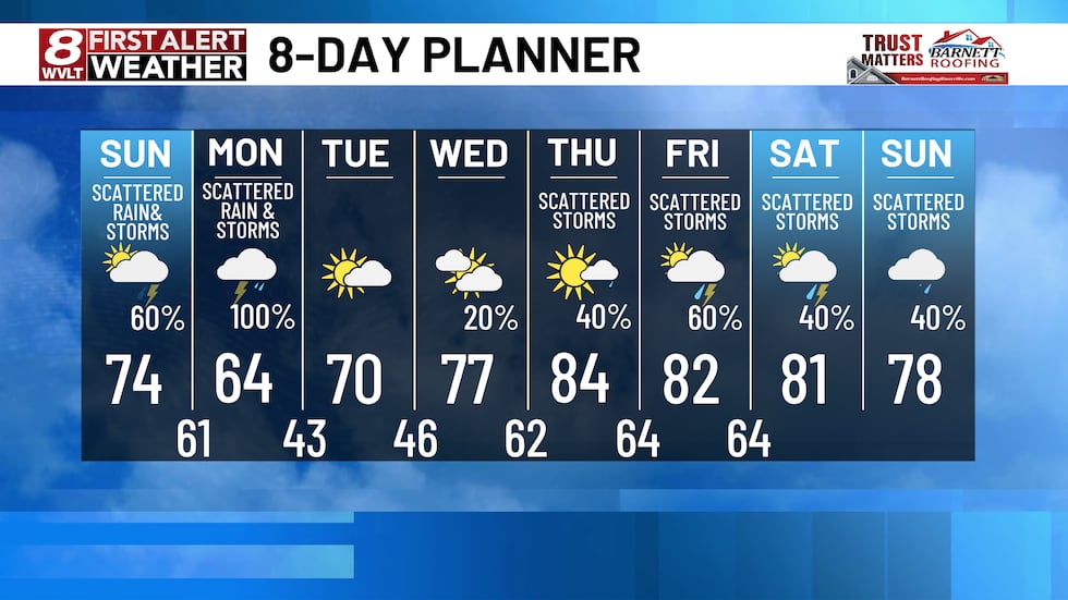
We hope to pick up around three quarters to an inch of rain on average with Monday’s cold frontal passage. Speaking of that front, while most of the main line of storms clears the viewing area by 7-8 a.m. EDT, our chance for another shot at rainfall will not be over. The storm system cold front is trailing the squall line by about 150 miles, so it will take until around mid day through the afternoon hours for that front to push east into North Carolina. That means will likely see a few more showers and possibly a thunderstorm or two during the afternoon as that boundary moves through the area.
We do not expect there will be a high threat for severe weather with these particular storms, but they could produce some healthy convective gusts and some small hail We will keep an eye on it in the WVLT First Alert Weather Center.
LOOKING AHEAD
We will get a chance to dry out on Tuesday, with sunshine returning to warm afternoon highs back up to around 70 degrees.
In fact, the pleasant weather regime may last all the way into Thursday, as the sub tropical high, sometimes referred to as the Bermuda High, builds west from its position over the western Atlantic Ocean across the southeastern United States.
This time of year, colder, polar air is still trying the build south into the mid latitudes where we live. At the same time, the tropics are heating up in the northern Hemisphere and that warm air will not be denied as Earth’s inclination to the sun increases.
This contrast leads to the windy weather we see during the month of March.
A battle for air mass dominance will take place just to our north Wednesday through the weekend.
The good news for us, and those that enjoy warmer weather is that we will see our afternoon high temperatures rise well into the upper 70s and lower 80s during this period.
The increasing southerly flow between the stalled out area of low pressure over the Ohio and mid Mississippi River Valley and that beautiful Bermuda high will help to push those temperatures 15 to 20 degrees above our average highs for early April.
While we may see some typical, afternoon thunderstorms form on the Cumberland Plateau and across the Smoky Mountains, in this more humid, and very warm air mass, the chance for rain will be low until Friday.
By Friday, the stalled boundary between cooler air north of the Ohio River and warmer air across the mid south will finally start its move to the south.
The slow moving front will lift scattered showers and thunderstorms across our area both Friday and Saturday.
By Sunday, we may be mostly sunny and dry again behind the cold front, but we will lose that pleasant glimpse of the summer months ahead.

Copyright 2025 WVLT. All rights reserved.


